

Introduction
Selecting the right Flight Ground Control Station (GCS) is crucial for drone and UAV operators, as it can significantly impact the efficiency and safety of their missions. With a wide range of GCS options available, it's important to understand the features and capabilities of different platforms to make an informed decision. In this blog post, we'll provide a comparative analysis of five popular UAV Ground Control Stations : Mission Planner, QGroundControl, UGCS, Betaflight, and iNav, discussing their pros and cons and which types of UAVs they are better suited for.
Unique Features of UAV Ground Control Stations
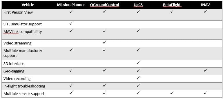
Mission Planner
Mission Planner is an open-source GCS software primarily designed for use with ArduPilot-based autopilots, making it a popular choice for drone enthusiasts and professionals. Here are some key features of Mission Planner:
- Intuitive User Interface: Mission Planner provides a user-friendly interface with a wide range of planning and monitoring tools.
- Extensive Planning Tools: Users can create complex flight plans, set waypoints, and define autonomous missions with ease.
- Real-time Monitoring: It offers real-time telemetry data, including GPS position, altitude, battery status, and more, allowing operators to monitor their drones during flight.
- Geofencing: Mission Planner supports geofencing capabilities to help ensure drones stay within designated areas.
- Extensive Compatibility: While primarily designed for ArduPilot systems, Mission Planner can also work with other autopilots, providing versatility.
Pros:
- Intuitive User Interface: Mission Planner provides an intuitive and user-friendly interface that allows users to easily plan and monitor missions.
- Wide Autopilot Compatibility: It primarily supports ArduPilot-based autopilots but can also work with other systems, providing versatility.
- Advanced Mission Planning: Users can create complex flight plans, set waypoints, and define autonomous missions with ease.
- Real-time Monitoring: Mission Planner offers real-time telemetry data, including GPS position, altitude, battery status, and more.
- Geofencing: It supports geofencing capabilities, ensuring that drones stay within designated areas.
Cons:
- Primarily for ArduPilot: While it is compatible with other autopilots, it is optimized for ArduPilot systems, potentially limiting options for users of other platforms.
- Limited Community Support: Compared to some other GCS options, Mission Planner's user community is smaller.
Best Suited For: Mission Planner is among those UAV Ground Control Stations which are best suited for users operating ArduPilot-based drones and those who prioritize ease of use and mission planning.
QGround Control
QGround Control is another open-source GCS solution that supports a wide range of autopilots, including PX4, ArduPilot, and more. It is known for its user-friendly interface and robust features:
- Cross-Platform Compatibility: QGround Control works on Windows, macOS, and Linux, providing flexibility for different operating systems.
- Mission Planning and Monitoring: Users can plan missions, set waypoints, and monitor telemetry data in real-time.
- Customizable: It allows users to customize the layout and widgets to suit their preferences and mission requirements.
- Advanced Features: QGroundControl supports advanced functions such as geofencing, dynamic geofencing, and offline mapping capabilities.
- Community Support: With an active user community, users can find help and resources for any issues they encounter.
Pros:
- Cross-Platform Compatibility: QGroundControl works on Windows, macOS, and Linux, providing flexibility for different operating systems.
- Mission Planning and Monitoring: Users can plan missions, set waypoints, and monitor telemetry data in real-time.
- Customizability: It allows users to customize the layout and widgets to suit their preferences and mission requirements.
- Advanced Features: QGroundControl supports advanced functions such as geofencing, dynamic geofencing, and offline mapping capabilities.
- Community Support: With an active user community, users can find help and resources for any issues they encounter.
Cons:
- No Specialized Focus: QGround Control is a general-purpose GCS and may lack certain specialized features for specific UAV types.
Best Suited For: QGround Control is a versatile GCS that can work well for a wide range of UAVs and users who value cross-platform compatibility.
UGCS (Universal Ground Control Software)
UGCS falls in commercial UAV Ground Control Stations Category, designed for both professional and industrial UAV applications. It offers a variety of features that cater to the needs of advanced users:
- Professional Mapping Tools: UGCS provides advanced mapping and surveying tools, making it ideal for aerial survey and photogrammetry applications.
- Multi-Drone Support: It can manage multiple drones simultaneously, allowing users to coordinate complex missions.
- Advanced Waypoint Planning: UGCS offers highly flexible waypoint planning capabilities, including terrain following and obstacle avoidance.
- Real-time Video Streaming: Users can access real-time video feeds from the drone's onboard camera for enhanced situational awareness.
- Remote Piloting: UGCS allows for remote piloting, making it suitable for BVLOS (Beyond Visual Line of Sight) missions.
Pros:
- Professional Mapping Tools: UGCS is an excellent choice for aerial survey and photogrammetry applications, offering advanced mapping and surveying tools.
- Multi-Drone Support: It can manage multiple drones simultaneously, making it suitable for coordinated missions.
- Advanced Waypoint Planning: UGCS offers highly flexible waypoint planning capabilities, including terrain following and obstacle avoidance.
- Real-time Video Streaming: Users can access real-time video feeds from the drone's onboard camera for enhanced situational awareness.
- Remote Piloting: UGCS supports remote piloting, making it suitable for BVLOS (Beyond Visual Line of Sight) missions.
Cons:
- Commercial Software: UGCS is a commercial GCS, which means users need to purchase a license, potentially increasing operational costs.
- Complex for Beginners: The extensive features may be overwhelming for beginners and those with simpler requirements.
Best Suited For: UGCS is ideal for professionals and industrial UAV applications, especially those in the mapping, surveying, and remote piloting sectors.
Betaflight
Betaflight is a GCS primarily designed for quadcopters and racing drones. It differs from the previous options, as it focuses on flight performance and configuration rather than mission planning:
- Firmware Configuration: Betaflight allows users to configure drone parameters, PID settings, and receiver setup to optimize flight performance.
- Real-time OSD: It provides an on-screen display (OSD) with telemetry data during flight, helping pilots monitor vital information.
- Racing Features: Betaflight includes specialized features for drone racing, including a configurable race mode.
- Active Development Community: It benefits from a strong community of users and developers, resulting in frequent updates and improvements.
- In-depth Tuning: Betaflight's focus on tuning makes it a great choice for those who want complete control over their drone's behavior.
Pros:
- Firmware Configuration: Betaflight specializes in optimizing flight performance through firmware configuration, PID tuning, and receiver setup.
- Real-time OSD: It provides an on-screen display with telemetry data, helping pilots monitor vital information during flights.
- Racing Features: Betaflight includes specialized features for drone racing, such as a configurable race mode.
- Active Development Community: Frequent updates and improvements are a result of the strong community of users and developers.
- In-depth Tuning: Betaflight is a great choice for those who want complete control over their drone's behavior and performance.
Cons:
- Not for All UAV Types: Betaflight is primarily designed for quadcopters and racing drones, limiting its suitability for other UAV types.
- Limited Mission Planning: It lacks advanced mission planning tools and may not be suitable for complex autonomous missions.
Best Suited For: Betaflight is the go-to choice for quadcopters, racing drones, and those who require precise control over flight performance.
iNav
iNav is a GCS designed for fixed-wing drones and aircraft. It combines autonomous mission planning with the capability to fly manually, making it suitable for a wide range of applications:
- Fixed-Wing Support: iNav is specifically tailored for fixed-wing drones, providing specialized features for them.
- Autonomous Missions: Users can plan missions with waypoints, takeoff, landing, and loiter points.
- Manual Control: It allows for manual control, making it versatile for both autonomous and piloted flights.
- Advanced Telemetry: iNav provides telemetry data for altitude, airspeed, and more, enhancing flight control.
- GPS and Navigation: It supports GPS-based navigation and return-to-home functionality.
Pros:
- Fixed-Wing Support: iNav is specifically designed for fixed-wing drones and aircraft, providing specialized features for them.
- Autonomous Missions: Users can plan missions with waypoints, takeoff, landing, and loiter points, making it suitable for surveillance and mapping missions.
- Manual Control: It allows for manual control, making it versatile for both autonomous and piloted flights.
- Advanced Telemetry: iNav provides telemetry data for altitude, airspeed, and more, enhancing flight control.
- GPS and Navigation: It supports GPS-based navigation and return-to-home functionality.
Cons:
- Limited Compatibility: iNav is primarily for fixed-wing UAVs, limiting its suitability for multirotor drones and other platforms.
- Less Versatile: It may lack the customization options and advanced features available in more general-purpose GCS.
Best Suited For: iNav is the ideal choice for operators of fixed-wing UAVs and aircraft, such as surveillance drones and mapping drones.
1. Software Platforms
| GCS | Software | Features | Compatibility | User Experience |
|---|---|---|---|---|
| QGroundControl | Open-source | Mission planning, real-time telemetry, customizable interface | PX4, ArduPilot | Intuitive, supports multiple OS (Windows, macOS, Linux, Android, iOS) |
| Mission Planner | Open-source | Advanced mission planning, parameter tuning, geofencing, real-time data logging | ArduPilot | Feature-rich but complex; requires a learning curve |
| UgCS | Proprietary | Multi-drone support, customizable flight paths, 3D mapping | DJI, PX4, ArduPilot | Professional-grade, user-friendly, supports complex missions |
| DJI Ground Station Pro | Proprietary | Seamless DJI integration, waypoint planning, automated flight paths | DJI drones only | Easy to use for DJI users, but limited to DJI ecosystem |
| Auterion Suite | Open-source | Cloud integration, AI integration, seamless edge-to-cloud workflows | PX4-based drones | Enterprise-ready, robust cloud features |
2. Hardware Options
| GCS | Hardware Options | Portability | Durability | Customization |
|---|---|---|---|---|
| Herelink | Integrated with a touchscreen controller | High (compact, lightweight) | Moderate (consumer-grade materials) | Limited (pre-integrated with QGroundControl) |
| CUAV GS Pro | Ruggedized GCS tablet | Medium | High (IP-rated, military-grade durability) | Limited |
| AeroGCS | Modular, PC-based or handheld | Variable | High (based on configuration) | High (various modular add-ons available) |
| DJI Smart Controller | Built-in touchscreen, DJI exclusive | High | Moderate | Minimal (locked to DJI ecosystem) |
| Harris UAV Console | Rack-mounted, industrial-grade setup | Low (fixed location setup) | Very High (designed for military use) | Customizable for military applications |
3. Key Features and Functionalities
| Feature | QGroundControl | Mission Planner | UgCS | DJI GS Pro | Auterion Suite |
|---|---|---|---|---|---|
| Mission Planning | Yes | Yes | Yes | Yes | Yes |
| Real-time Telemetry | Yes | Yes | Yes | Limited | Yes |
| Multi-drone Operations | No | Limited | Yes | No | Yes |
| 3D Mapping and Waypoints | Basic | Basic | Advanced | Limited | Advanced |
| Cloud Integration | No | No | Yes | No | Yes |
| Artificial Intelligence (AI) | No | No | No | No | Yes |
4. Cost Analysis
| GCS | Software Cost | Hardware Cost | Best Use Case |
|---|---|---|---|
| QGroundControl | Free | Variable (depends on hardware) | Hobbyists, research, open-source projects |
| Mission Planner | Free | Variable (depends on hardware) | Research, small-scale UAV operations |
| UgCS | Subscription-based | Moderate to High | Commercial, industrial mapping projects |
| DJI GS Pro | Free | High (limited to DJI hardware) | DJI ecosystem users |
| Auterion Suite | Subscription-based | Variable (based on hardware) | Enterprise UAV operations |
5. Applications by Industry
| Industry | Recommended GCS | Why? |
|---|---|---|
| Military | Harris UAV Console, UgCS | Rugged build, multi-drone capability, real-time mission adaptability |
| Commercial Mapping | UgCS, Auterion Suite | Advanced 3D mapping, multi-drone operations, AI and cloud integration |
| Hobbyist | QGroundControl, Mission Planner | Free, open-source, and easy-to-learn platforms |
| Enterprise | Auterion Suite, UgCS | Scalable solutions with cloud features and AI integrations |
| Inspection | DJI GS Pro, Herelink | User-friendly interfaces, easy waypoint navigation, compact hardware for portability |
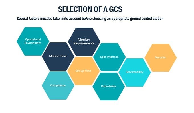
How to Select a UAV Ground Control Station:
Ground control stations come in many shapes and sizes and the price can differ significantly. Before initiating the design and purchase of a ground control station it is important to define the “need to have” and “nice to have” requirements. These are impacted by the operations for which the ground control station is being used, and the capabilities of the unit being controlled.
Conclusion
The choice of UAV Ground Control Stations is a critical decision for UAV operators, as it impacts mission success, efficiency, and safety. Each of the GCS options discussed in this comparison has its own set of strengths and weaknesses, making them more suitable for specific types of UAVs and mission requirements.
- Mission Planner is best suited for users of ArduPilot-based drones who prioritize ease of use and mission planning.
- QGroundControl is versatile and cross-platform, making it a solid choice for a wide range of UAVs and users.
- UGCS excels in professional and industrial applications, especially for mapping, surveying, and remote piloting.
- Betaflight is the preferred choice for quadcopters, racing drones, and users who want precise control over flight performance.
- iNav is tailored for fixed-wing UAVs, making it ideal for surveillance, mapping, and other fixed-wing applications.
Ultimately, the choice of GCS depends on your specific UAV type, the complexity of your missions, and your preferences in terms of customization and features. Careful consideration of these factors will help you select the right GCS to enhance the success of your UAV operations.